How to use a compass and map
The Timeless Reliability of Maps and Compasses in Navigation
In the realm of wilderness exploration, the combination of a map and a compass constitutes a fundamental navigation toolkit whose relevance and reliability have stood the test of time. Unlike modern digital devices, these tools do not rely on batteries or satellite signals, making them particularly robust under a variety of environmental conditions. This traditional method of navigation, while perhaps seen as old-fashioned by some, offers crucial benefits that can make the difference between finding your way and losing it in the wild.
The Enduring Utility of Topographical Maps
A topographical map is more than just a paper with trails marked; it is a detailed representation of the physical features of a terrain. These maps are meticulously crafted to show contours, elevations, water bodies, vegetation areas, and man-made structures such as trails and roads. The contour lines on a topographical map are particularly valuable as they illustrate the shape of the terrain: closely spaced lines indicate steep slopes, while lines farther apart suggest a flatter surface. This allows hikers and adventurers to assess the difficulty of the terrain ahead and plan routes that match their skills and time constraints.
Understanding how to read a topographical map is crucial. It provides an overview not only of the paths one might take but also of potential hazards or difficult terrain. Additionally, these maps often include crucial survival information, such as the location of water sources, which can be lifesaving in emergency situations.
The Unmatched Precision of the Compass
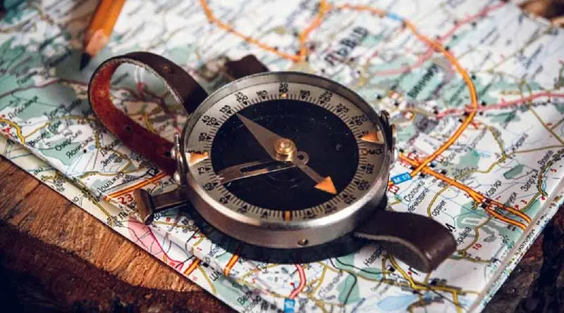
A compass, on the other hand, is a simple yet profound instrument used for finding direction relative to the Earth’s magnetic poles. Its primary component is a magnetized needle that spins freely to align itself with the magnetic field of the Earth. When used in conjunction with a topographical map, a compass allows an adventurer to orient the map correctly with the geographical directions, ensuring that the terrain features on the map match those in the real world.
Using a compass effectively involves understanding basic principles like ‘bearing’—the direction to or from an object—and ‘azimuth’, which is a compass bearing expressed in degrees. By aligning the compass with the map, one can establish a line of travel that corresponds to a desired direction in the physical environment. This is crucial for maintaining a correct path or for navigating back to a safe location if lost.
Integrating Maps and Compasses for Effective Navigation
Navigating through the wilderness with the aid of a map and compass is more than a skill—it’s an art. These tools have synergized over centuries into a reliable method for explorers to find their way across unfamiliar terrain. Here’s a detailed breakdown of how to effectively use these essential navigation aids together:
Step 1: Orient the Map
The first critical step in using a map and compass together is to orient the map. This entails setting the map’s north to coincide with the magnetic north that your compass is indicating. To do this:
- Lay your map on a flat surface.
- Hold the compass flat in your hand or place it on the map.
- Rotate the map and compass together until the compass needle lines up with the north marking on the map. This ensures that the map’s orientation reflects the actual landscape directions, making it easier to navigate accurately.
Step 2: Identify Your Location
Once the map is oriented:
- Use natural landmarks, such as rivers, peaks, and valleys, which can be easily identified both on the map and in your environment.
- Compare these features with what you see around you to pinpoint your exact location on the map. This step is crucial as it forms the basis of all subsequent navigation decisions.
Step 3: Plan Your Route
With your current location identified, you can plan your route:
- Assess the terrain and your capabilities—consider factors like distance, elevation changes, and potential hazards.
- Mark your route on the map using a pencil or a waterproof marker. This helps in visualizing the journey ahead.
- Use the compass to measure the direction of travel from your current location to your next waypoint or destination. This is known as setting your heading.
Step 4: Take a Bearing
Taking a bearing helps to translate the planned route into a walkable path:
- Place the compass on the map so one edge connects your current location with the next point in your route.
- Keeping the edge of the compass baseplate fixed on these two points, rotate the compass housing (the part that moves and includes the degrees or azimuth ring) until the north lines on the baseplate align with the north on the map.
- The direction arrow on the compass now points to your travel direction. Read the bearing (in degrees) from the index line or mark on the compass housing.
Step 5: Monitor and Adjust
As you start moving:
- Hold the compass in front of you with the direction of travel arrow pointing straight ahead.
- Ensure that the compass needle stays aligned with the bearing line you set earlier. This confirms you are moving in the right direction.
- Periodically check your actual location on the map using landmarks and features to ensure you are following the intended route.
- Make adjustments as needed, especially if deviations occur due to obstacles or changes in the landscape.
The combination of a map and a compass is a powerful toolset for navigation, providing reliability and accuracy when modern technologies might fail. By understanding and practicing these steps, adventurers can enhance their navigation skills, leading to safer and more enjoyable explorations. Each phase, from map orientation to monitoring progress, is vital in ensuring that every step taken is a step in the right direction, deepening the connection with the natural world through skilled navigation.
The map and compass are still essential navigational aids in an era where digital technology dominates. They do not suffer from technological failures and provide a reliable method for route finding and orientation in the wilderness. For anyone serious about outdoor adventures, learning to proficiently use these tools is not just a skill but a necessary part of safe exploration.


